Life presents us with many opportunities and challenges. We have had a significant challenge this year with health issues. Our biggest challenge, Cancer, has stalled our travels and explorations. But, recently, the treatments for Cancer have been reduced to maintenance doses, and we have been able to resume our travels. As full-time Rvers, we love spending time in the forest and seeing the beauty of nature.
Unfortunately, Last winter, my husband Joe developed a rare form of Cancer that forced us to come off the road for a while so that he could receive cancer treatments. Thank God his Cancer is dormant now, and he feels well once again! However, he needs to be in the Memphis area once a month for maintenance Chemo treatments. We are spending a little bit of time in northern Alabama this winter. We arrived on December 2nd and will stay here until December 19th.
So, our main reason for traveling to Arley, Alabama, is its proximity to Memphis. It is only a four-hour drive, so it is easy for Joe and I to travel to the Memphis Area for Chemo and then return to Arley.
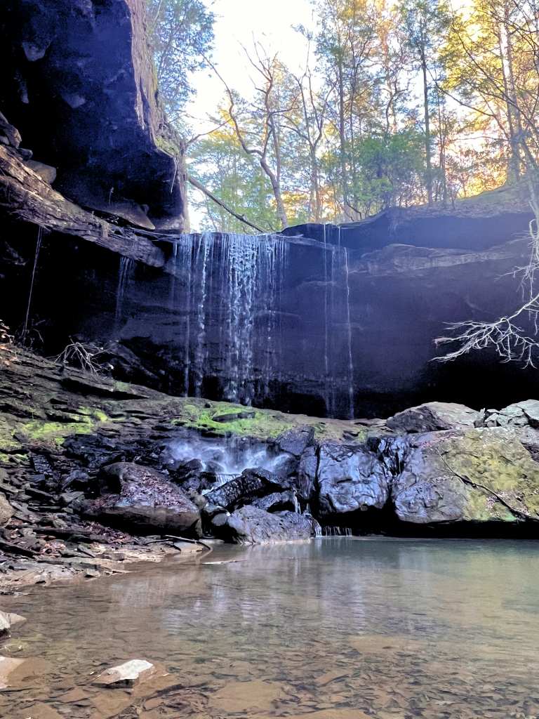
Because our campground is located on the edge of Bankhead National Forest, we can explore this beautiful area. The Sipsey River area in the forest is absolutely spectacular! Because it is December in the south, the colors we saw ranged from soft brown to mossy green. The creek was crystal clear in most places with a green tint. In other places, it was like a mirror, reflecting the beauty and splendor of the forest trees and rocks. Everything was so quiet! We enjoyed God’s world in its purest form. There were no human sounds except our footsteps rustling through the fallen autumn leaves!
We love waterfalls, so this week, we went exploring. Because we are unfamiliar with the area, I consulted my All Trails Subscription. I discovered that waterfalls are abundant within an hour of camp. We chose to hike the Sougahoagdee Falls because although it’s long, All Trails said it was easy. Ha!!
We are both in our mid-sixties, so we found this trail challenging. I rate this trail as moderate or even difficult in some spots!
Our All Trails App said the trail was 3.4 miles in and out and would take about one hour and twenty minutes to complete. Now, I can certainly see it taking an hour and twenty minutes if one is fifteen years old and that person runs the entire distance! But we are in our mid-sixties! The hike took us about three to four hours!
When we began our adventure from our motorhome to the waterfall, we used Google Navigator to direct us to the Trailhead. I was worried that Google Maps had done us wrong because, close to the Trailhead, Navigator led us to a remote one-lane dirt road in the middle of nowhere. When I say remote, I mean very remote! There was not a sign of human life anywhere.
Here are some directions for folks who would love to explore this trail. From US-278 heading west, turn right onto County Road 63. Travel 6.6 miles to Hickory Grove Road. Turn right onto Hickory Grove Road. The Trailhead is located 4.2 miles up the road on the left.
There is only room for two or three cars to park. But limited parking was not a problem because we were the only ones there! After we parked, we called family members and let them know our location because we wanted loved ones to know our whereabouts.
We have created a video of the trail to bring you along on our hike to Sougahoagdee Falls, so come join us! We hope you enjoy the video!
